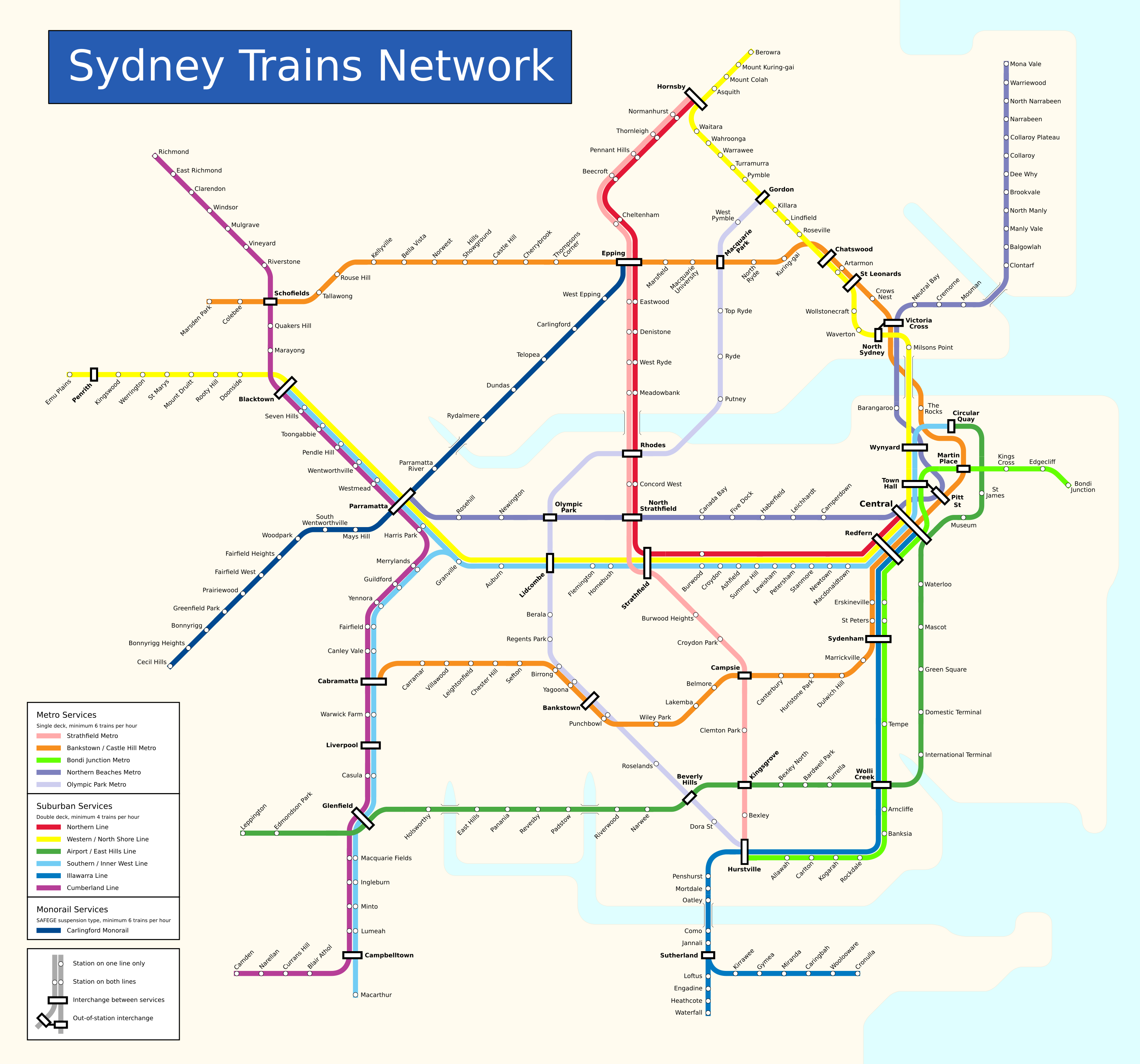
A hypothetical Sydney heavy rail map
Git repository: Link
Over the years there have been more than a few railway network maps created for Sydney, Australia. All sorts of official, unofficial, hypothetical, geographical, and historical ones can be found via a websearch with your favourite search engine. This is my contribution to that pile of pictures.
The above map represents a lot of proposals actually implemented and opportunities taken instead of missed. The map was constructed as a 3000x2800 SVG, but due to rendering consistency issues it has been exported into PNG format here. Click it to open a full scale version. Since emphasis is on a "what if" for heavy rail lines, no grid, index, light rail, or other transport services have been included.
There are 12 lines depicted, including 6 suburban double deck, 5 metro single deck, and 1 suspension monorail. For the most part the colour of preexisting lines has been made consistent with recent official maps.
Suburban lines:
Metro lines:
Monorail lines:
Despite everything else this may be the most controversial idea here. In the past Sydney had a very poorly designed, low capacity monorail loop between the CBD and Pyrmont. What is proposed here is much closer to monorail systems found in countries like Japan and China where monorails are constructed to provide services like a heavy rail line. The technology would be a modified SAFEGE system to allow for 6 car trains and 80km/h service speed.
The Southern / Inner West, Airport / East Hills, and Cumberland lines all overlap track, as do the Northern and Strathfield lines. All other lines use their own dedicated track pairs exclusively. This means the hypothetical network is made up of 9 independent sectors overall.
Despite the above, there is some overlap with intercity services. Southern Highlands services would operate via Glenfield, Wolli Creek, and Sydenham, which makes up for the lack of express East Hills services from Campbelltown. Central Coast services would still operate via Hornsby, Epping, Strathfield. In both cases minor interference between sectors is possible.
Other modes of transport have been intentionally left out. This includes an extensive hypothetical light rail network covering the eastern suburbs, as well as the CBD, parts of the inner west, and a few lines around Parramatta. There is also potential for important bus rapid transit services between the North Shore and Northern Beaches, as well as one around Liverpool.
Finally, there are three options for extending public transport to the second Sydney airport at Badgerys Creek. The Airport / East Hills line could be extended, the Carlingford monorail could be extended, or a new branch of the Western line could be constructed from St Marys as in current official maps. In the long term all three options may be ideal. The current proposal of the solitary St Marys branch may have the unacceptable downside of overcrowding on the Western line.
It is interesting how increased connectivity in a transit network leaves less and less room for the distortions necessary for the clean schematic lines expected of such maps.
At some point I would like to go back and make a map that includes some of the mentioned unmapped features. Although at that point it may be more practical to use computational routing methods.
{% endblock -%}